What do you get when you cross
Roman ruins with modern-day computer technology and painstakingly precise
surveying data? An archaeological Web site that boasts almost as many
special effects as the blockbuster Gladiator.
Like Rome, the Corinth Computer
Project—directed by Dr. David Gilman Romano Gr’81 CGS’99 —wasn’t built
in a day. Romano, keeper of the Mediterranean section of the University
Museum and adjunct associate professor of classical studies, set out a
dozen years ago to study and map the orientation of one building to one
road in the ancient colony of Corinth on the northeastern Peloponnesus
of Greece. Since then, his modest project has expanded—with the help of
some 70 Penn undergraduate and graduate students —to a “stone-for-stone”
computerized drawing of the entire excavated city of Roman Corinth, along
with features of the land for miles around. The results can be viewed
at (http://corinth .sas.upenn.edu);
a book and CD-ROM will eventually follow.
“I don’t think any other
project of this kind has this much data about a city, in terms of a digital
record, all linked together,” Romano says. The map on the Web site offers
information on the chronology, function and physical characteristics of
everything from drainpipes to altars to mosaics.
“The accuracy is in the
centimeter-to-millimeter range because of the field work that’s been done,”
says Nicholas Stapp GFA’00, who has served as Romano’s research associate
since 1995 and oversees his lab. The surveys of every above-ground monument—aided
by a laser-equipped device known as an “electronic total station”—have
been combined with pre-existing archaeological plans and other data to
produce a precise and seamless plan of the city.
Corinth, a Greek port city
which once rivaled Athens in size and power, was destroyed by the Romans
in 146 B.C. One hundred and two years later, the Romans, led by Julius
Caesar, founded a new city on top of the old. The ruins have been under
excavation for the past century.
First posted this past spring,
the Web site has received more than 11,000 hits, drawing the attention
of major scientific institutions, archaeology scholars and the occasional
fifth-grader. It was highlighted in the April issue of Science
magazine.
Visitors to the Web site
can find three-dimensional models of the remains of what may be one of
the oldest amphitheaters of the Roman world, where gladiators and bears
once performed. After “flying” over the city to get a sense of its terrain,
they can step into the forum as it exists today by using a 360-degree
photographic panorama. Stapp is also working on a digital video tour of
the site, along with a gallery of interior 3-D photographic panoramas,
and promises that the result will be “a major armchair-tourist” experience.
Depending on their interests,
Stapp says, visitors to the site can turn on and off layers of information.
“If you are a scholar interested in studying city planning, for
example, you could go to our site, filter everything out but the drainage
material and see what the waterworks was [like] for this ancient city.”
Over the summer, Romano
and his students embarked on a new computer-mapping project in the Mugello
Valley of Tuscany, in conjunction with an Italian university. His long-term
goal is to create a research center that can continue this kind of work
at different archaeological sites around the world in affiliation with
the University Museum and several schools at Penn. He also has been promoting
the idea of creating a master’s program in mapping and field archaeology
to acquaint students with technology like Geographic Information Systems
software and remote sensing.
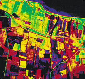
The significance of such
tools is evidenced by Romano’s discovery of a second Roman colony at Corinth,
founded between 70 and 80 A.D. during the reign of Vespasian. “That all
comes from remote sensing and the creation of precise digitized maps,”
he notes. ”We wouldn’t have been able to do this without computers.”
And while he doesn’t foresee
such methods replacing old-fashioned pick-and-shovel work, Romano firmly
believes that the new digital tools he and his colleagues have created
will be “extremely valuable” to future archaeologists.