Unearthing the world’s oldest tavern while reconstructing daily life in ancient southern Mesopotamia.
By Beebe Bahrami | Photography courtesy Lagash Archaeological Project
Sidebar | Ancient Lagash
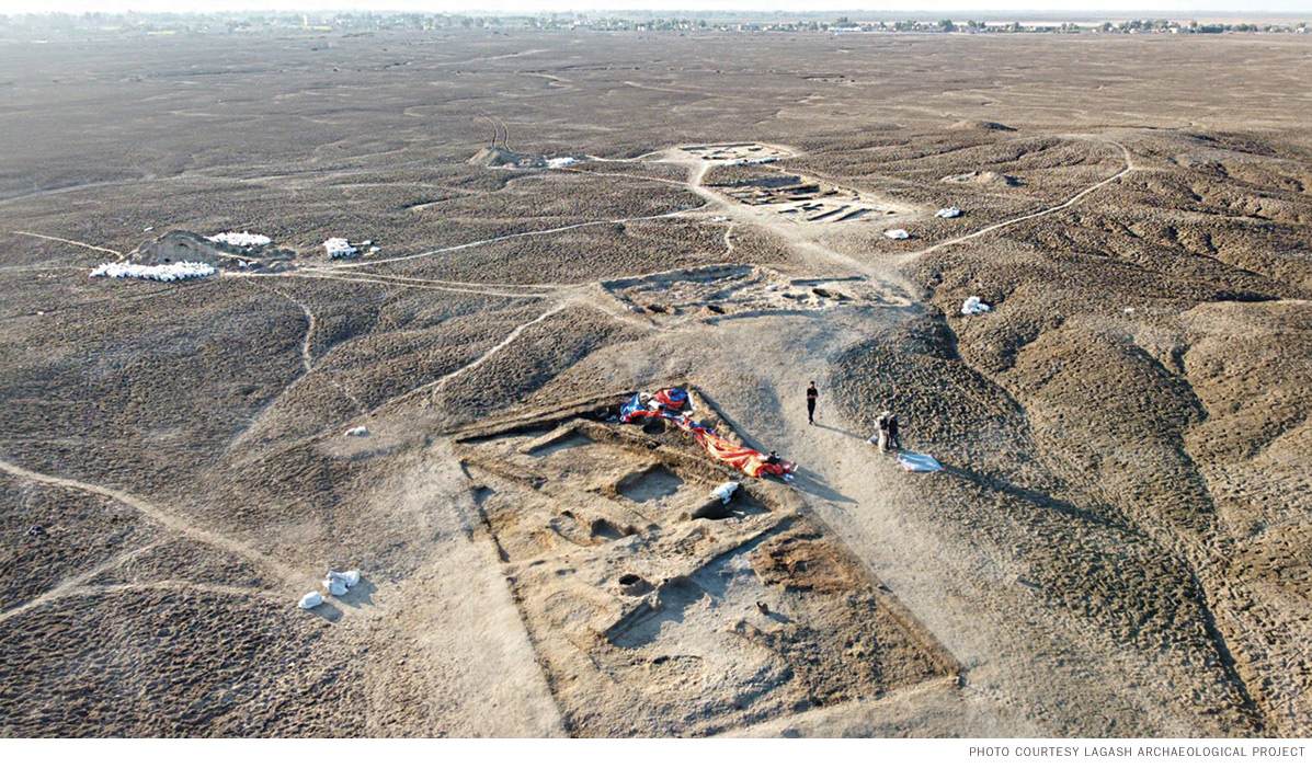
It is the spring of 2022 and hard going. An excavator diligently chips away densely packed clay earth within the walls of an archaic mudbrick building. Hard-packed tawny earth stretches toward the horizon in every direction. Sara Pizzimenti, an archaeologist and ceramicist from the University of Pisa and one of the season’s co-field directors, stands before the sunken pit her crew is working on: Trench 3 in Area H at the archaeological site of Tell al-Hiba. The Sumerians would have known it as Lagash, an ancient city built midway between the Tigris and Euphrates rivers in southern Mesopotamia, some 350 kilometers south of Baghdad and 225 kilometers north of Basra.
Pizzimenti turns to a camera filming the work—the video can be seen at web.sas.upenn.edu/lagash—and explains what the team has uncovered: the 4,700-year-old walls of what is, so far, an unclear structure from the beginning of the Early Dynastic period. There is an alley beyond the building, she adds, and beyond that another building. An ancient neighborhood is appearing from beneath the sediments, but for now, all efforts are focused on removing collapsed mudbrick inside the nearest building—whose caved-in roof they have already removed. “We do hope to find the floor,” she says, and adds, “with something on the top, maybe.” It’s hard not to catch the hopeful note in her voice.
Seven months later, that hope delivered. The team returned in the autumn of 2022 and got back to work on Area H, expanding Trench 3 and opening others, all the while continuing careful horizontal excavation. There were several interconnected walled areas. One, an open-air space, revealed a large, ash-filled oven that could have cooked huge amounts of food for a large group of people. In a neighboring, once roofed, room—the very one the excavator had been removing the collapsed mudbrick from—the cleared floor revealed a double-potted zeer, an ingenious ancient refrigeration device that cooled anything within the inner pot’s belly. Close by, the team found more than a hundred upturned conical beakers and bowls that had tumbled at some point from no longer existent shelving on the wall above. Many vessels still contained fish remnants, animal bones, and the residues of other foods and drinks. The drink residue is most likely beer, the most popular beverage of ancient Mesopotamia. The complex also contained an open-air courtyard seating area with low benches and tables. The pieces began fitting together.
“The moment I realized we were in front of a ‘tavern,’” Sara Pizzimenti wrote in an email, “has been full of emotion. I immediately called Holly, sharing with her my hypothesis of interpretation.”
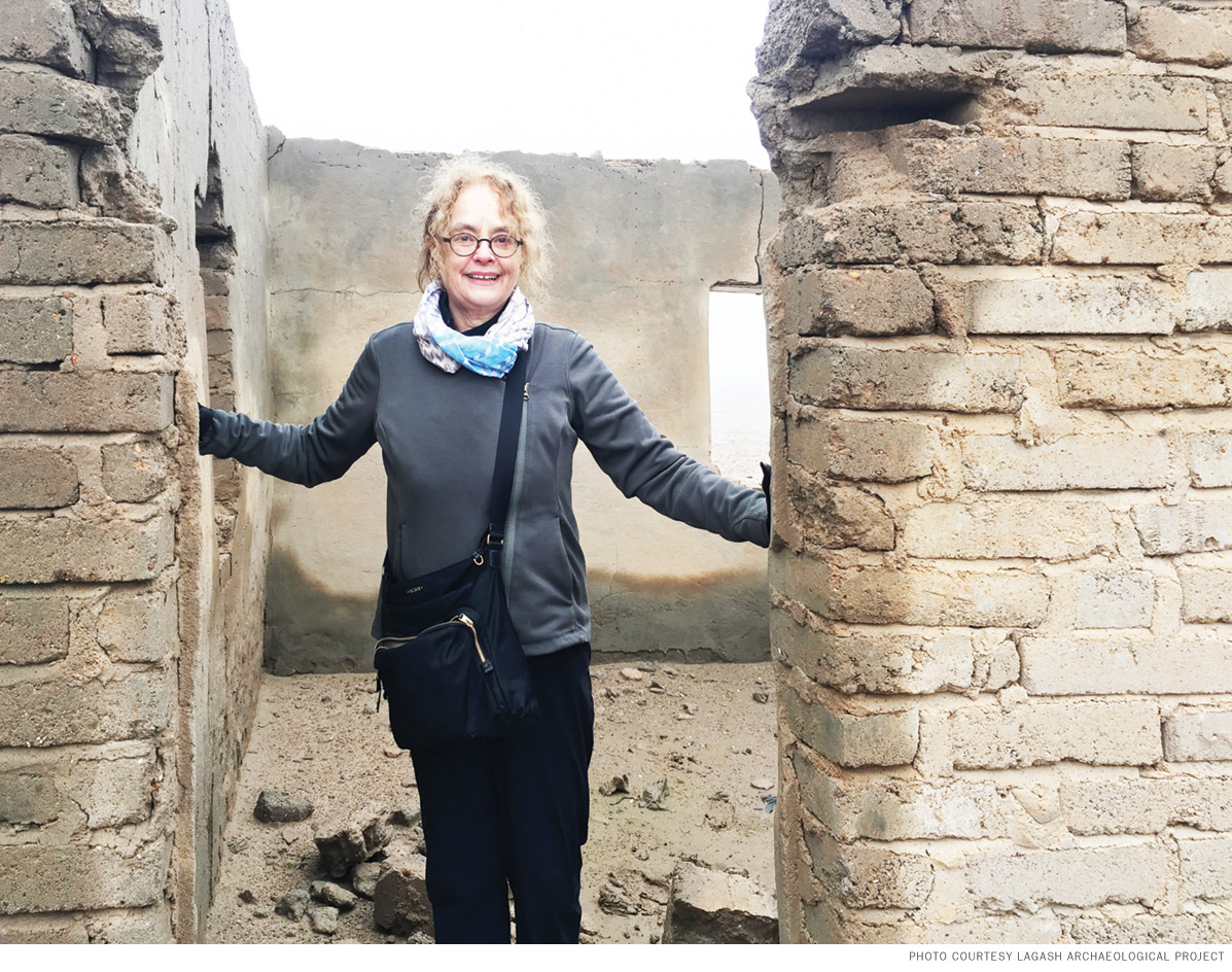
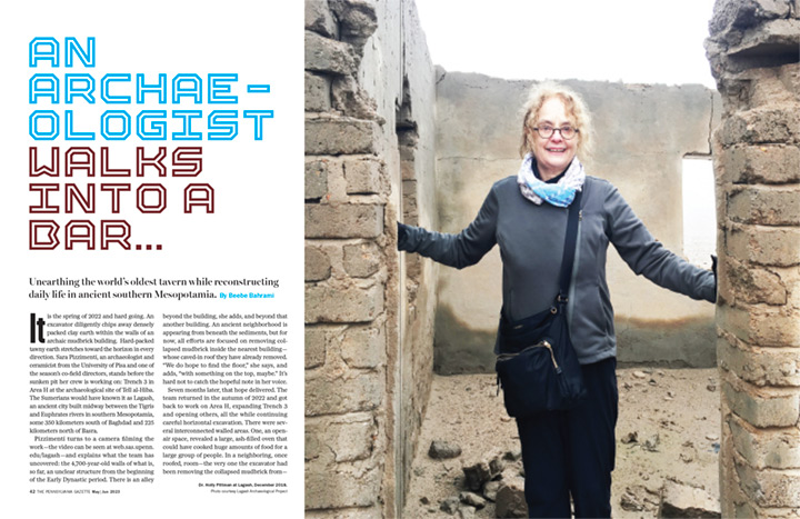
Holly Pittman—Bok Family Professor in the Humanities in Penn’s art history department, curator in the Penn Museum’s Near East Section, and now the director of this massive archaeological project—recalls that moment vividly. “I was working in the [dig] house, [when Sara] called and said, ‘We have a tavern!’” she says. “I got the car, and I got the police.” No one on the team can travel anywhere without police escort for security, even though things are moving more and more toward stability in Iraq. In six minutes, the time it took to drive between the house and the site, nearly everyone was there. “We were all very excited,” she says.
They had discovered the oldest known tavern in human history.
Beyond the predictable media coverage—which ranged from CNN to Smithsonian magazine to Stars and Stripes—their find provides a rare glimpse into ancient daily public life. The archaeology of Bronze Age Mesopotamia, including previous work at Lagash in the 1960s and ’70s, has by and large focused on palaces, temples, administrative centers, and elites. The Lagash Archaeological Project (LAP) hopes to change that, by coaxing from Lagash’s complex settlement more information about the people who produced the city’s food and large-scale crafts. Their work in Area H—picked because its pottery production activity suggested it might be an industrial craft neighborhood—will continue to expand, both in that area and on to other neighborhoods whose roads, alleys, and buildings have been indicated by complex aerial and surface mapping work already undertaken by the team.
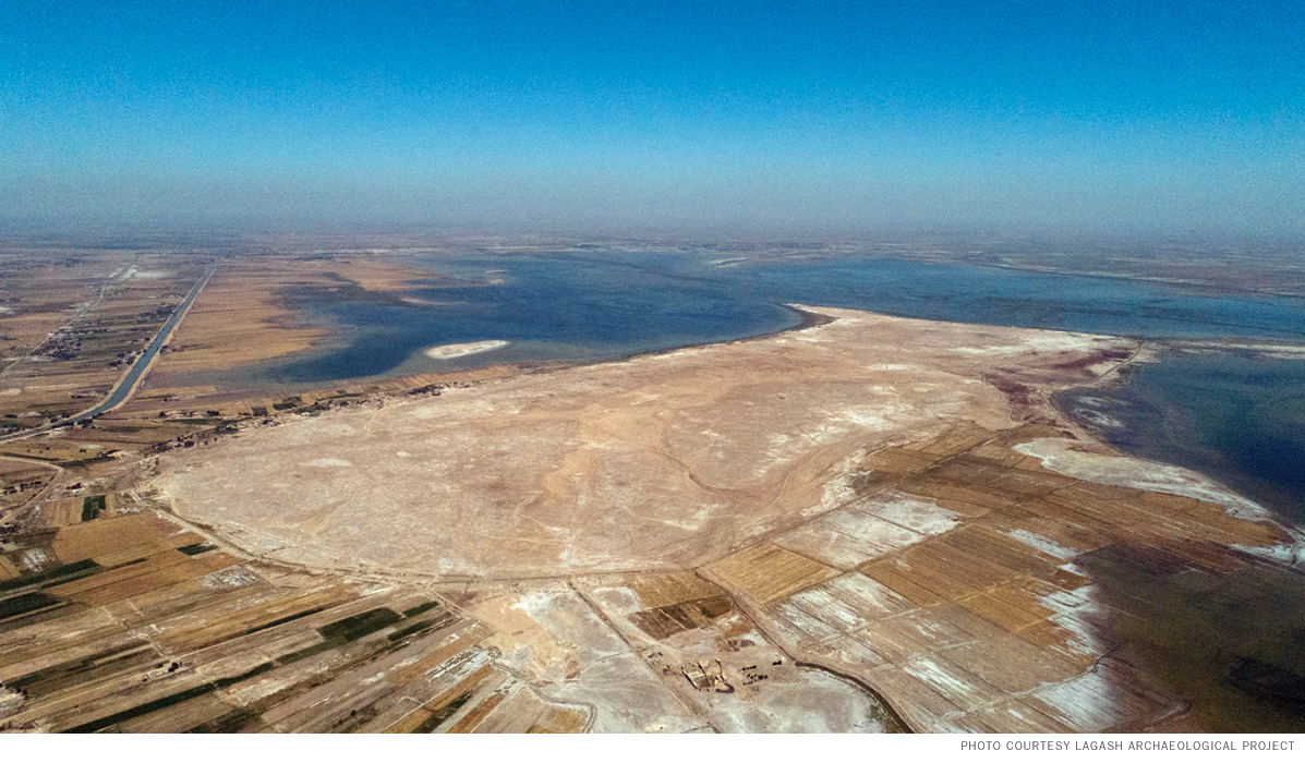
From above, Tell al-Hiba, which takes its name from the nearby village al-Hiba, looks like a rounded water jug with a bird-beak spout jutting into a body of water that can sometimes, in wet years, surround it on three sides. At 3,600 meters long and 1,900 meters wide, the tell (the term refers to a mound created from the debris of past settlements) is considered one of the largest urban centers of Early Dynastic southern Mesopotamia, which existed in the third millennium BCE, when the first cities and city-states emerged in human history. More broadly, the site was occupied from the fifth millennium BCE to around the middle of the second millennium BCE, or around 7,000 to 4,000 years ago.
Some 5,000 to 4,000 years ago, Lagash might have been one of the more intense urban centers for the industrial-scale production of ceramics, as well as of food production and crafts such as textiles and worked shell and stone, all in the midst of a vast trade network connecting Mesopotamia to regions including Iran, the Indus, Anatolia, and the Arabian Plateau. From these far-flung places came items not found in Sumer, such as timber and hard stone for building, precious stones and metals, and more. What southern Mesopotamia had a lot of was mud, reeds, and water, plus good pastures for herds, and select fertile fields, courtesy of mud deposits brought by the seasonally flooding rivers. It was, and remains, an environment that offered the basics of life: food, drink, shelter, and clothing. For something more, trade was essential; and this was the period that aimed for something more.
The tell is a few meters higher than the surrounding plain and villages as a result of its dense Bronze Age urban occupations, structures over time being built atop prior structures. It was built from locally abundant materials: packed mud, mudbrick, reeds, and clay. So the ruins present a puzzle to reassemble, as centuries of flooding, wind, water, and erosion have washed away certain levels while leaving others intact.
This is also why Pittman and Pizzimenti (now the LAP’s sole field director) have from the start determined that the best way forward is with slow and careful horizontal excavation. This removes sediment in thin layers, allowing the team to follow the natural lines of the structures and discern which ones were contemporary with one other and which date from earlier or later periods.
Archaeological interest in Lagash dates back to the 19th century, but the first comprehensive and scientific efforts took place from 1968–1978 with joint research led by Vaughn Crawford from the Metropolitan Museum of Art and Donald Hansen from New York University’s Institute of Fine Arts. Joining them was the archaeologist Edward L. Ochsenschlager, now professor emeritus at Queens College, New York, who, fascinated by discovering that the ancient site’s material culture reflected parallels with that of the modern village in al-Hiba, turned his research toward an ethnoarchaeological study comparing the two, Iraq’s Marsh Arabs in the Garden of Eden, published in 2004 by the Penn Museum and now available through the University of Pennsylvania Press.
The Iran–Iraq war, from 1980 to 1988, cut short their work at Tell al-Hiba, but a window opened in 1990 that led Hansen to return, this time with Holly Pittman, who had recently earned her PhD at Columbia University while also working at the Met (where Crawford was her boss) and who had just joined Penn as an associate professor of art history.
Pittman grew up in eastern Washington state and came east to study chemistry at Bryn Mawr College. Midway through, she realized chemistry wasn’t her calling. She took a break, got a job in New York City, and saved enough money to travel to Europe for a few months. Peak moments during her 12-country backpacking tour included Florence’s art museums and an active archeological dig on the north coast of Crete. There, a French team was excavating at Malia. She spent some time there, visiting the work and the ruins of the Minoan civilization.
She had left the US with $700 and returned with $50 plus a wealth of experiences and a strong new sense of direction. She finished her undergraduate degree at SUNY Binghamton, majoring in history, and went on to graduate work at Columbia, studying under Near Eastern art historian and archaeologist Edith Porada. Porada directed Pittman to study the Scythians, which she did for her master’s. At the same time, Pittman accepted an offer to work for the Metropolitan Museum as a curatorial assistant on Mesopotamian and Iranian material.
That job put her firmly on the path not only of Mesopotamia and Iran, but also of finding her passion for glyptic (engraved symbolic) art, and for the Bronze Age and the formative periods in ancient Near Eastern cultures. It also put her in the orbit of the Penn Museum’s joint projects with the Met, including Tal-i Malyan in Iran. She also worked at sites in Cyprus, Turkey, and Syria. Soon after finishing her doctorate and coming to Penn, in 1990 she joined Hansen at Lagash.
It was an incredibly productive season. But any promise of returning was cut short by Iraq’s invasion of Kuwait and the ensuing Gulf War, followed by the US-led invasion of Iraq and deposing of Saddam Hussein in 2003, which plunged the country into a period of tragic destruction and conflict.
While there was no possibility of returning to Iraq, Pittman pursued her interests in the Neolithic, Chalcolithic, and Bronze Ages on many excavations in Turkey, Syria, and Iran. As a curator in the Penn Museum’s Near East Section, she was active in mounting several exhibits, such as on the royal treasures and cemetery of Ur, and most recently, for the Middle East Galleries: Sharing Our Past exhibit spaces, which opened in 2018.
Hansen died in 2007, leaving Pittman the archive containing all the work done at Lagash from 1968 to 1990. Working for 10 years with a team of dedicated students, Pittman oversaw to completion the material’s analysis, digitization, and publication. The three resulting volumes, being published by Brepols, are coming out in rapid succession: volume one was published in 2022, and volumes two and three will be released soon. This laid the groundwork for new work at Lagash, which would build on Crawford and Hansen’s prior research on monumental, administrative, and elite life, and integrate it with the LAP’s new research centered on the life of the nonelite—including people involved in the city’s food and craft production and their domestic spaces and neighborhoods. And now, a tavern.
It wasn’t until 2017 that Iraq achieved enough stability for archaeological work to resume. Through the Iraq State Board of Antiquities and Heritage, many projects came back on line. In southern Iraq, the British Museum, led by Sebastian Rey, returned to ancient Girsu (modern Tello) just north of Lagash, and an Italian team led by Davide Natale (Rome) and Andrea Polcaro (Perugia) returned to ancient Nigin (modern Tell Zurghal), just south of Lagash. These three cities once made up a unified city-state and were connected by a canal that proceeded southward toward the Gulf. Pittman realized it was an important time to return to Lagash. She applied for and received the permit.
One irony of 30 years’ worth of setbacks due to war, civil instability, and, in 2020, a global pandemic, is that advances in archaeological science and technology are now allowing the LAP to move forward efficiently, accurately, and much faster than prior times. Many of these methods are also cheaper and less destructive than straight excavation. Among them: geological core samples; walking surface surveys (especially those in 2022 using GPS and Geographic Information Systems to map the team’s systematic surface artifact survey, which covered 1,783 plotted points within the tell and revealed where certain ancient activities like pottery production concentrated); drone photography and mapping; and magnetometry that can map subterranean structures in high detail.
“What we’re trying to explore is variety within the regular people,” Pittman explains. “Both variety in terms of craft specialization but also in terms of relative wealth, however you measure that, by either food or extra ornaments, or size of architecture, in order to compare these different neighborhoods. We also want to explore that through time. Our operating hypothesis right now is that maybe in the Early Dynastic I [around 2900-2600 BCE], in this earlier phase, craft production was perhaps more centralized within the domestic context, or within small-scale neighborhoods. And then later, we’re thinking that maybe by Early Dynastic III [around 2500-2334 BCE], Lagash becomes a very important industrial center as well as important population center and agricultural center.”
All of these questions are harder to answer without understanding what was happening in the ancient landscape, the relationship between people and the frequently shifting courses of the rivers, and also the sea, including where exactly the ancient coast of the Persian Gulf was in relationship to the city-states of Sumer. During the four seasons of the LAP that have unfolded so far, geoarchaeologist Reed Goodman, a doctoral student in the Penn Graduate Program in Art and Archaeology of the Mediterranean, under the direction of Liviu Giosan at the Woods Hole Oceanographic Institution, has been overseeing the geological coring at Lagash to understand the ancient environment, including the history of the shifting rivers, marshes, and sea. The team has augured and drilled a number of core samples, including one going 25 meters deep, providing a continuous record of sediment rich in ecological data stretching back 30,000 years from the present.
“Lagash as a site is a perfect test for when it comes to looking at the ancient environment,” Goodman says, “because texts tell us that the city and the city-state was close to the ancient shoreline of the Persian Gulf. We also know that that shoreline was changing during the third millennium [BCE], and that at the same time—though we don’t know exactly why—the city of Lagash itself took on a sacred role within the city-state as political power moved north.”
This is also when textual sources (Sumerian written in cuneiform script) begin speaking of conflicts between city-states, such as over access to fertile land. It is also a time, with growing interdependence between polities, that reflects greater alliances. Goodman is working to understand how the environment, and especially water dynamics, influenced these processes.
But because the rivers can shift courses, and also are influenced by the ebb and flow of tides from the nearby sea, as well as by wind and erosion, sediment can constantly get mixed in this environment. Core sampling in southern Mesopotamia is tricky. “You need to get a lot of different dating techniques,” Goodman explains, “and you need complementary data sets to start to build a confident argument of what the environment was like and at what time in history.” This means not only capturing sediment samples from carefully selected areas around and on the site for characterization and dating, but also correlating those sedimentary environments with the archaeological and textual data of the site and region.
Goodman has been running core samples through an X-ray florescence core scanner, interpreting their calcium, bromine, and potassium contents to learn about the different types of environments where these sediments were deposited. X-radiography from the same machine looks at the structure and content of the sediment, indicating the presence, for instance, of tidal flats, from a time before the city existed, when the area was submerged beneath a shallow sea. As he honed in on the environment around the Early Dynastic period in Lagash, he was surprised by what he found.
Since the Neolithic, herding and farming activity in the Zagros mountains, located to the northeast, began to increase erosion and sedimentation via its two major rivers, the Karun and Karkheh, which flow into the Persian Gulf east of the Tigris and Euphrates—so much so that they eventually built out an alluvial fan that separated the Sumerian cities and the sea.
“By the third millennium BCE, the Karun fan had largely cut off Sumer from the sea, creating an increasingly restricted estuary, and without the scouring actions of the tides, the floodplain built out rapidly to infill the former coast.” These early cities and city-states then found themselves separated from the sea and more dependent on the rivers right at the time when they were reaching their greatest growth. It made for a more and more politicized landscape, leading to both competition and alliances.
The “water-rich ecology” of fourth millennium BCE Lagash began to dry out, forcing communities to respond. “They can either dig in and say, ‘We’re going to maintain these cities that have our important temples and institutions of government,’ or, ‘We’re going to move and follow these deltas that are moving rapidly farther south.’ But because these cities are so symbolically important—and now you have enough technical knowledge and community organization to increase and expand irrigation—they dug in.”
In 2018, with permit in hand, Pittman’s most critical need to launch the project was for an experienced archaeologist fluent in Arabic who could coordinate the LAP.
Zaid Alrawi—the LAP’s project manager, and the Penn Museum’s Projects Manager of Southern Mesopotamia—grew up in Baghdad. As a boy he went to the field with his father, an archaeologist who worked on sites throughout Iraq. His father preferred that Alrawi spend time in the outdoors, in nature, learning about his country’s heritage, over playing in the streets of Baghdad. When Alrawi was deciding on a career, he realized how much exposure he’d already had to archaeology and decided to devote his life to it. He worked for the State Board of Antiquities and Heritage, earned his BA in archaeology from the University of Baghdad, and then came to the States, where he earned his master’s at SUNY Stony Brook before pursuing a doctorate at Penn State, focusing on third millennium BCE southern Mesopotamia and its ancient landscapes and economies in the areas around Lagash.
In Philadelphia to interview for a post-doc position at the Penn Museum—where he arrived early to take in the new Middle East Galleries and the materials from Ur—Alrawi serendipitously ran into Reed Goodman, a friend and former Penn State classmate, who told him he should meet Pittman, who was just then looking for a project manager. That evening when Alrawi returned home, he had an email from Pittman; their subsequent exchange changed the course of his life. He was exactly the person Pittman needed for this crucial role. In less than two weeks, the two were on a plane to Baghdad and then heading south to Lagash.
On that trip, “there were special moments,” Alrawi recalls. At Tell al-Hiba, the old dig house where Pittman had resided in 1990 had become a ruin. “She went to one particular room, and it was emotional because she was talking and walking right and left, talking about things that had happened on that night or this night and how insects and scorpions were crawling down.” To Alrawi, it was clear: “She was supposed to be there,” he says. “She’s not somebody who just got licensed to excavate …. She was somebody who has history with the site” and the people who were part of it.
“There is a strong bond from the community to the project,” he elaborates. “Everybody’s on the same page. They love each other. They respect each other. That makes me happy.”
The Crawford and Hansen excavations in the 1960s and ’70s forged a continuing bond of good will with locals, who remember them to this day. That has persisted with Alrawi and Pittman’s efforts and team. From the start, they first met with officials and village elders, discussing their plans and important matters concerning the village, community, and site, including how they can best contribute to the community. In 2022, this translated into providing funds for the villagers to make improvements to their primary school. The hope is to do more for the community in coming years as they raise funds. Another crucial aspect is to train Iraqi archaeology colleagues in the field techniques and technology they use at Lagash, and to be able to pay them.
Many institutions have contributed to the work at Tell al-Hiba: the Iraq State Board of Antiquities and Heritage, the universities of Pennsylvania, Cambridge, and Pisa, the Metropolitan Museum of Art, the Woods Hole Oceanographic Institute, National Science Foundation, National Geographic, the Janeway Foundation, the Archaeological Institute of America, and National Endowment of the Arts, among others. But above all, without the extensive personnel and funding support from the Penn Museum, none of this could have happened.
But back to the tavern. One strange thing is it seems to just have been abandoned in the middle of its daily activity. The bowls are piled up, and there is still a lot of food in some of them. You can almost still feel the pleasing chill of the beer in the zeer, or the fragrant smells of roasting fish or baking bread coming from the large oven, but there is no evidence, yet, of a destructive event. That the tavern is from the earlier part of Lagash’s Early Dynastic period, not hundreds of years later when the city was sacked by Lugal-zagesi of Umma around 2375 BCE, makes the abandonment feel haunting.
There’s a lot more excavation to do, Pittman stresses, both in Area H and in other neighborhoods. But “from what we can tell,” she says, “they just walked out and shut the door. They just left things on the shelves.
“We have a store down the block,” she adds, about her neighborhood in Philadelphia, “a coffee shop, and they went out of business. They just locked the door and shut it. Lots of stuff was still left in this place. So, you know, they just walked out with the last lunch.”
SIDEBAR
Ancient Lagash
Lagash grew quickly to become one of the largest cities in the third millennium BCE, during what archaeologists call the Early Dynastic (ED) period, which spans from around 2900–2334 BCE. The period’s name derives from the appearance of the first dynastic rulers. The ED is further divided, at Lagash, into ED I, the earlier half of the third millennium, and ED III, the later part of the third millennium, which came to an end when Lagash was sacked, first by the neighboring king Lugal-zagesi of Umma, and then again soon after, by Sargon of Akkad, who unified Sumer with the northern Akkadian Empire in 2334 BCE.
Before the Early Dynastic period at Lagash, there were at least two other distinctive periods. The Ubaid, around 6000–4000 BCE, was characterized by small self-sufficient villages along the river plain where people foraged the marshes for fish, shellfish, and birds, and varieties of water-adapted cereals. During the subsequent Uruk period, around 4000–3100 BCE, settlements were still small. This was most likely when the first settlement of Lagash appeared, probably “simply as a cult center,” Pittman says. “This is all hypothetical,” she adds. “That was probably also true of Girsu and of Nigin. These places that were originally cult centers, as they became habitable, they were settled.”
It is with the Early Dynastic period, beginning some 4,900 years ago, that archaeologists see the first settlement sizes of a scale considered urban. The city of Lagash ultimately formed into a unified city-state with its urban neighbors, Girsu to the north, and Nigin, to the south. Also theoretical but plausible, it seems at some point political and religious activities centered on Girsu, while Lagash was mostly devoted to food and craft production.
After Sargon conquered Lagash, the city shrank in size but remained occupied. It rose again after the fall of the Akkadian Empire, around 2150 BCE, as a regional political center, but by the end of the third millennium BCE it declined once more and became mostly a cereal grain producing center for Ur.
By around 1600 BCE, Lagash was largely uninhabited, except for a brief occupation around 3,000 years ago, and then much later, during the Islamic period, sometime after the seventh century CE.
Today Lagash is surrounded by several villages that engage in traditional herding, farming, foraging, fishing, and crafts that feel uncannily familiar to early Mesopotamian times. —BB
Beebe Bahrami Gr’95 is an anthropologist and the author of numerous nonfiction books, most recently The Way of the Wild Goose: Three Pilgrimages Following Geese, Stars, and Hunches on the Camino de Santiago. Her essays and articles focus on cultures, travel, archaeology, nature, and more.